The 8 January 2006 Earthquake (Mw 6.7) Offshore Kythira Island, Southern
Greece: Seismological, Strong-motion, and Macroseismic Observations
of an Intermediate-depth Event
Konstantinos I. Konstantinou, Ioannis S.
Kalogeras, Nikolaos S. Melis, Moissis C. Kourouzidis, and George
N. Stavrakakis
See also the publication
in Seismological Research Letters, Vol 77, No 5 September/October
2006, 544-553
On 8 January 2006 at 11:34 GMT (13:34 local time),
a strong earthquake with a moment magnitude of 6.7 occurred
in southern Greece, off the eastern coast of the island of Kythira.
The epicentral coordinates as estimated by the European Mediterranean
Seismological Centre (EMSC-CSEM, http://emsc-csem.org were 36.31°N,
23.24°E, and the focal depth was 60 km. The shock was felt
in a spatially extended area that covered Greece, Italy, Turkey,
Egypt, Cyprus, Israel, Syria, Jordan, and Lebanon. Despite the
large magnitude of the earthquake, the reported damage was not
extensive mainly due to the intermediate focal depth. No casualties
were reported and the structural damage to buildings was limited
to the islands of Kythira and Antikythira and to the city of
Chania, western Crete. Furthermore, landslides and/or rockfalls
were reported only at the village of Mitata (Kythira island),
where the main square and the road were damaged due to a landslide.
In this article we take advantage of a multitude
of available observations to give a detailed report on this
most recent large intermediate-depth earthquake. First, we describe
the temporal and spatial distribution of the mainshock-aftershock
sequence and summarize all available moment tensor solutions
reported by various agencies. Then, we present preliminary analysis
of strong-motion recordings in an effort to check the relationship
between the shaking caused by such an event and the influence
of both attenuation and local geological conditions. Macroseismic
data collected from the whole of Greece also are included and
utilized toward understanding the regional intensity attenuation
pattern. Finally, we give an overview of the implications of
such an event in terms of regional seismotectonics and seismic
hazard.
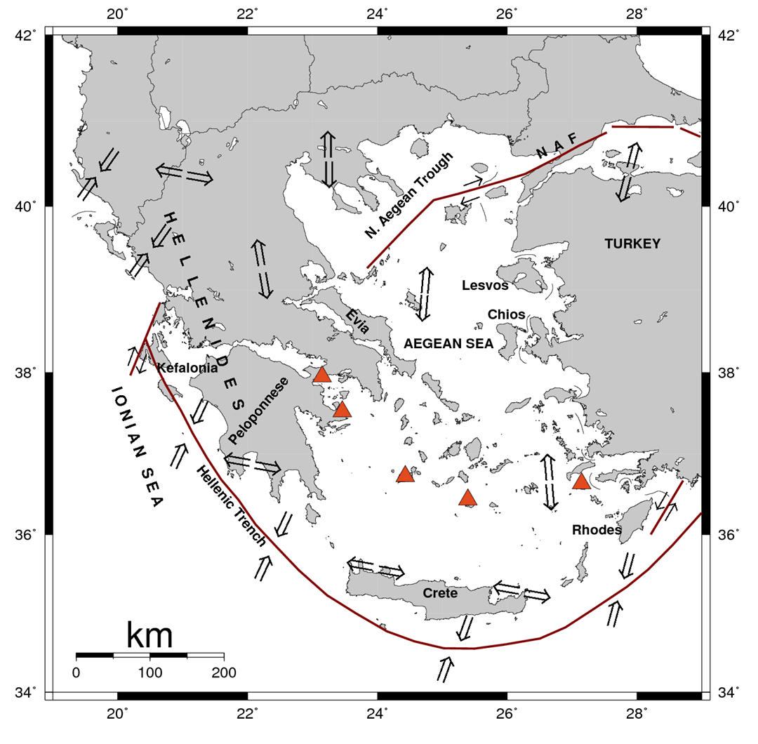
SEISMOLOGICAL OBSERVATIONS
Intermediate-depth earthquakes in the broader
area of south-western Greece are related to the southern Aegean
subduction zone, which is referred to as the Hellenic arc (figure).
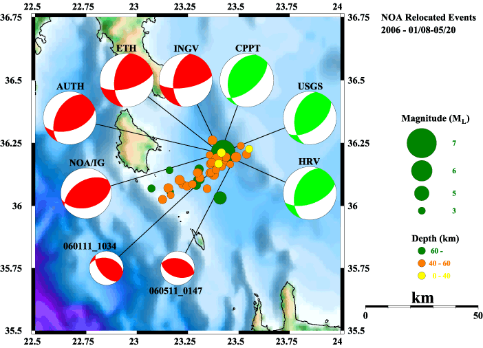
The mainshock as well as several of its aftershocks
(8 January to 20 May 2006) were recorded by the Institute of
Geodynamics' seismological
network. The results of the recordings analysis (manually
picking of P- and S-phase arrival times and their inversion)
are consistent with the results reported by several institutes/agencies,
which show a predominently reverse slip component. In the map
the circle The circle size is proportional to the local magnitude
of each event, according to the scale shown at the right side
of the plot. In a similar way, the focal depth follows the color
scale shown at the right side. All available moment tensor solutions
for the mainshock and two of its aftershocks also are plotted.
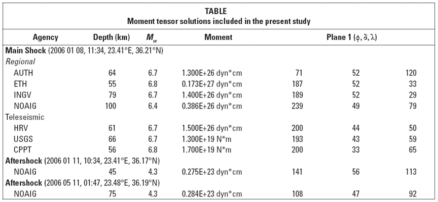
The linked table shows
the moment tensor solutions included in the study.
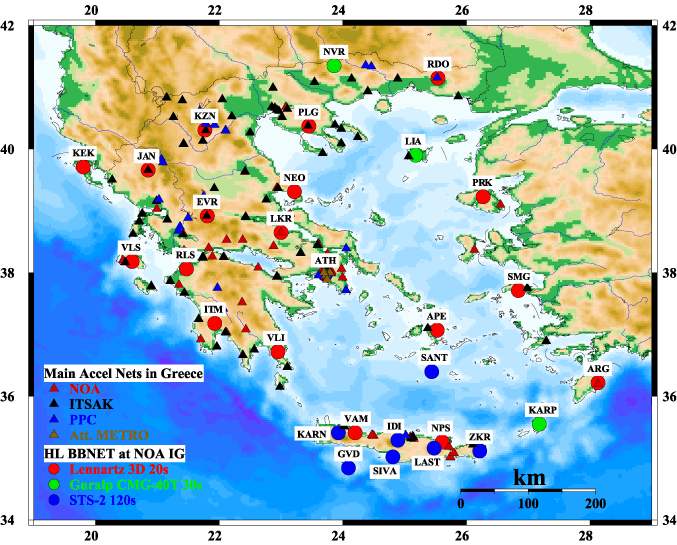
STRONG MOTION OBSERVATIONS
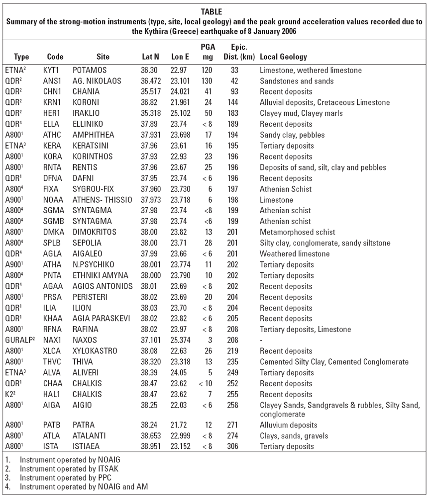
The strong motion recordings included in the study
came from the accelerographs
operated by the Institute of Geodynamics, ITSAK (www.itsak.gr)
and PPC. The linked table
gives information about the sites and the PGA recorded.
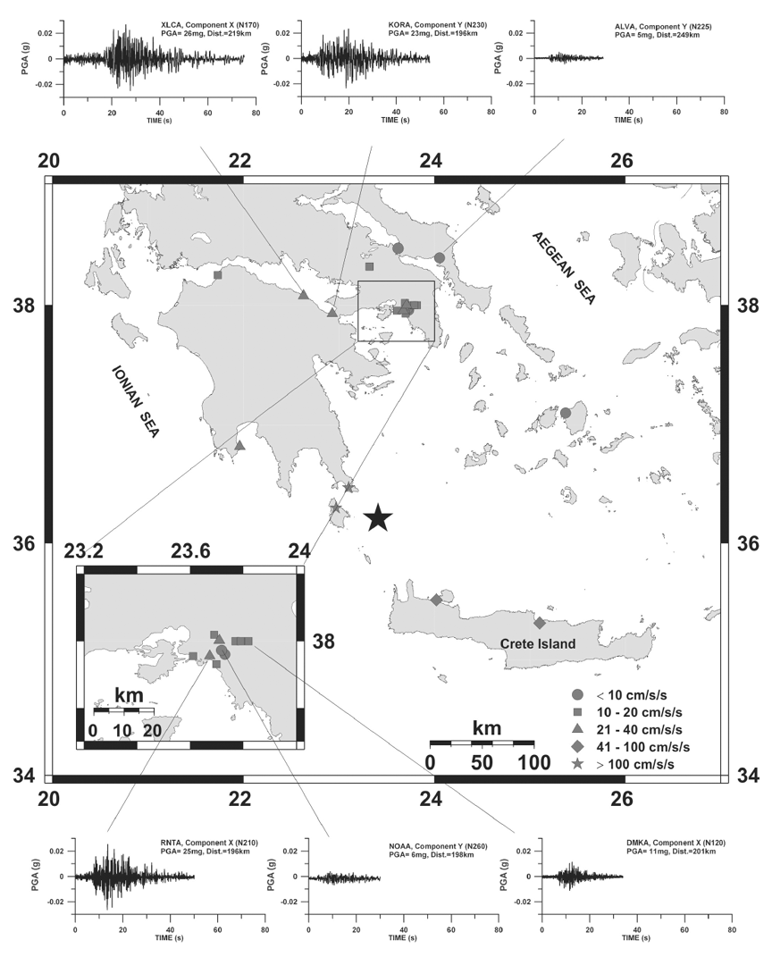
Some examples of strong ground motion recorded
during the Kythira earthquake by a number of instruments in
and around the Athens metropolitan area are showed in the figure.
The star represents the epicenter of the mainshock and the different
symbols indicate PGA values registered at those locations.
The linked table
summarizes the PGA (g), PGV (cm/s) and PGD (cm) values calculated
from the NOAIG strong motion instruments. Follow the number-links
to view the respective graph.
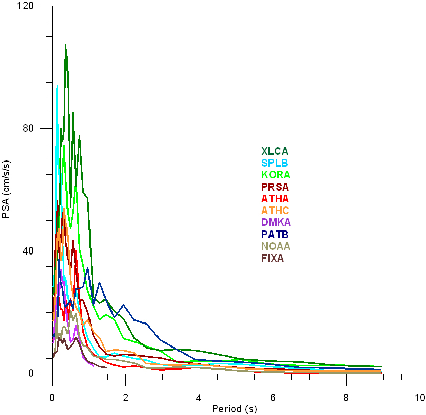
Analysis of the accelerographs showed that
the corresponding response
spectra appear to be dominated by long period (up to 2.5s)
strong ground motion, which is in contrast to observations of
strong ground motions recorded during near-field events (dominant
periods usually shorter than 0.5s). A comparison
of near field (dashed line) and far field (continuous line)
pseudoacceleration response spectra for PGA of the same order
(around 20-30mg) was performed for 4 sites (PRSA, KORA, XLCA
and ATHC) and showed the existence of the long period waves
recorded by the strong motion instruments due to the Kythira
earthquake in all situations, although the spectral accelerations
do not vary much for the four cases.
MACROSEISMIC OBSERVATIONS
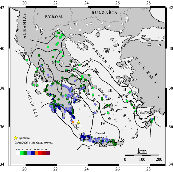
According to first reports, the Kythira earthquake
was felt in most parts of Greece, so questionnaires were sent
to all the prefectures of the country. In total 666 questionnaires
were sent and 304 were completed and returned by the local authorities.
The reported answers clearly indicate that despite its large
magnitude, the earthquake did not cause serious damage owing
to its large focal depth. For example, at Potamos village (on
Kythira island) situated only 35 km from the epicenter, the
reported intensity was only V+. At the village of Mitata, where
the most serious damage occurred (intensity VII+), local site
amplifications appear to have been responsible for the relatively
severe shaking, since similar observations also were reported
after another intermediate-depth earthquake in 1903. A map
of isoseismals curves derived from the macroseismic
data following the methodology of Schenkova et al. (2006),
based on a kriging method. Moreover some simple
statistical diagrams concerning the macroseismic observations
are presented.
